June 3-4, 2022 —
After visiting Mount Rainier National Park for the first time in 2019, I fell in love with the park. I once ranked it 3rd out of the 16 national parks I had visited circa 2020. Though I had only spent two days there – one hindered by rain and snow – it left an impression on me. More significantly, it led me to make a tremendous resolve. Despite having zero mountaineering experience in 2019, I decided I wanted to summit Mount Rainier. It seemed like a ludicrous goal at the time. If I did accomplish said goal, it would certainly take years of learning and experience. I also did not know when I’d return to Washington to even start the necessary mountaineering journey. Living in Indiana, it seemed unlikely.
Plan your trip to Mount Rainier National Park
Enter Eli Sitchin
Eli and I met through our Aerospace Engineering major at Purdue in 2016. Initially, I was intimidated by his intense passion for our major, his noticeable smarts, and big personality. After a couple of years, however, we discovered our shared passion for climbing. This led to lots of 1-on-1 top rope sessions at Purdue’s rec center, followed by many trips to Red River Gorge in 2020, 2021, and 2022. When we graduated from undergrad in May of 2020, Eli continued at Purdue in pursuit of a Masters. My location in nearby Indianapolis allowed us to continue climbing together and allowed our friendship to grow.


In addition to climbing, Eli is an avid mountain climber. He grew up in Washington and – throughout his youth – had summitted Cascadian peaks like Mount Baker, St. Helens, Adams, and Rainier with his dad and various outdoor groups. He was getting to the point in his life where we wanted to take his mountaineering passion into his own hands. For that, he needed – at a minimum – a new partner.
Enter Paul.
Eli knew I had a passion for the outdoors and that I was in generally good physical shape. It didn’t take long for us to talk about the possibility of climbing mountains together. Eventually, this led to me booking a flight to Washington in July of 2021. He agreed to guide me up Mount Adams, the second highest peak in the state at 12,276 feet. Though altitude presented a potential issue for me, the south climb up Adams seemed simple and nontechnical. Without the presence of glaciers, the climb is essentially a steep hike through a snowfield.


Summitting Mount Adams was – relatively – a piece of cake. I had no issues with the altitude, likely due to my experiences at high elevation in Bolivia. Additionally, I didn’t struggle much with the heavy pack or 6,721 feet of elevation gain. My performance even impressed Eli: a tough feat to accomplish. While I didn’t anticipate Rainier to happen for another few years, plans changed shortly after. By the end of 2021, we were already making plans to summit Rainier. A few months later, I booked my flight and the plan was in motion.
Training for the Summit
For the record, attempting to summit Rainier with my level of experience is not recommended. Rainier is covered in glaciers, and even the easiest route – Disappointment Cleaver – requires glacial navigation. Knowing how to navigate glaciers safely and prepare for things like crevasse falls and avalanches takes time and experience. Generally, it’s recommended to learn the proper techniques on the ground and practice on smaller glaciated mountains, like Mount Baker. But, I’m an impatient person, so I skipped the prerequisites. Neither Eli nor his more experienced dad opposed my early induction onto Rainier’s summit, however. So, we proceeded with the plan.
Preparing for the physical aspect required no additional effort on my part, since most of my hobbies keep me rather active. Between my summit of Mount Adams and scheduled summit of Mount Rainier, I continued to climb, run, bike, hike, swim, and work out.


Preparing for the technical aspect required some more work. I purchased Freedom of the Hills, a well-renowned climbing and mountaineering book, per Eli’s suggestion. There, I read about all the mountaineering skills I could potentially need on Rainier. To learn how to execute those skills, Eli planned to provide me with a one-day “snow school” while on Rainier. We would climb to high camp – Camp Muir – on day 1, practice mountaineering skills on day 2, and summit on day 3. It seemed like a solid plan, and I was ready – and excited – to climb this mountain.
One Week to Go…
If you read my post about my first visit to Mount Rainier, you’ll know that it taught me how unpredictable mountain weather is. Mountain weather in Washington is especially unpredictable and – at best – predictably lousy. One week out from our scheduled summit day, the forecast was looking grim.
Snow, clouds, gusty winds, and low temperatures were all predicted during our 3-day summit attempt. For early June – when our trip was scheduled – this was uncommon. Early to mid-June is typically a good time to try and summit peaks in Washington. During this time, snow bridges are still strong and weather is generally clear and sunny: the perfect conditions. In 2022, however, Rainier was receiving lots of snow in both May and June. The trend continued into our summit window, spelling trouble for us.
Quickly, I tempered my expectations. During our three-day summit schedule, there was a small window of potentially good weather on the morning of the second day. Day 3 looked borderline dangerous due to forecasted heavy snowfall, so we had to attempt to summit by day 2 if we wanted a chance. Eli and I agreed to a new plan: climb to Camp Muir and engage in a shorter snow school on day 1, get a few hours of sleep, wake up at 2 AM, and attempt to summit early on day 2. It was a crazy plan, but there was a chance it would work. Besides, the Disappointment Cleaver route – which we were taking – was usually well-marked by guided groups. Weather-wise, we hoped for the best, but expected the worst.
While it might not have been the “worst,” the weather was still pretty damn bad.
Preparing to Summit
I flew into Seattle late on Thursday, June 2nd. Eli and I drove to his house and his parents helped us prepare our mountaineering packs for the next day. I fit as much as possible into my pack. In addition to the backpacking gear I already owned, my pack also held the following:
- Ice axe
- Crampons
- Prusiks
- Harness
- Helmet
- Snow shovel
- Avalanche probe
- Avalanche beacon
- Tent
- Snow goggles
- Snow anchors
- Food
My pack weighed about 50 pounds, and Eli’s nearly 65 pounds. We were as ready as we could be.

Day 1: A Rough Day on the Mountain
The next morning, Eli’s dad made us a huge breakfast. I tried not to be nervous as we loaded up the car and began driving to Rainier. After reading about all of the things that can go wrong on a mountain – and being reminded of them by Maria – I was struggling to control my anxiety.
Before we left, Eli’s dad reminded us of a very important thing:
“It doesn’t matter if you make it. What matters is that you come back.”
Ricardo Sitchin
I held onto that quote and vowed to let it guide our decision-making. I knew there was no shame on us if we didn’t summit. The mountain wasn’t going anywhere, and I could always come back. What mattered is that Eli and I stayed safe on the mountain.
The one piece of good news was that – despite less-than-ideal weather – our first day was relatively simple. Climbing to Camp Muir, situated at 10,188 feet, only required navigation of a snowfield. So, even in crappy conditions, we were certain we could make it to Camp Muir. From there, we would have time to evaluate our situation and decide whether we should attempt to summit or not.
A Rainy Drive to Mount Rainier
“Crappy conditions” were exactly what we faced when we drove into Mount Rainier National Park. For much of the drive to Paradise – our departure point for Camp Muir – we faced torrential rains. Rain would translate to snow, clouds, and whiteout conditions on the mountain. The downpour continued when we arrived at Paradise. Before picking up our climbing permit at the ranger station, I nabbed another passport stamp and bought a poster & hat. At the ranger station, the attendant informed us of exactly what we feared: the weather was bad, no successful summit attempts had been made in the last few days, and many groups that had registered for a permit had either bailed or not shown up.
Oh boy.
Eli and I grabbed our permit, returned to the car to retrieve our bags, and began the trudge through Muir Snowfield at 1 PM. The snowfield rises 4,788 feet from Paradise (at 5,400 feet) to Camp Muir (at 10,188 feet). Even in good conditions, it is a tough hike, especially when you add 50+ pounds of gear onto your back.
Beginning to Summit Mount Rainier
The rain stopped before we began our hike, providing a respite from the bad weather. As we started to hike through the snow, we encountered many people descending from the slopes above. However, we found very few people joining us in ascending those slopes. Apparently, we were one of the only groups crazy enough to do it. That wasn’t a surprise.
We climbed our first 1,000 feet in about an hour. Eli and I took a break near Panorama Point, a spot typically popular with hikers. On a day like today, however, there were none to be found. While conditions in our immediate vicinity were favorable, we saw clouds looming ominously above us. The further we climbed, the closer we got to entering the clouds.


During the next 1,000 feet of our ascent, we met two other groups. One group had turned around after discovering the whiteout conditions above. The other group was still working their way to Camp Muir, unsure if they would make it or turn back. Shortly after passing the second group, we entered the clouds. In a matter of minutes, visibility reduced to mere feet in front of us. I couldn’t distinguish between the ground and the sky and could barely make out the rocks we had been using to guide our ascent. The wind picked up, and snow began to pelt us.
We were in a whiteout.


The Whiteout
The next 2.5 hours were a total blur. During this time, Eli and I took sporadic breaks. We followed distinct footprints until about the 8,000-foot mark, then began following “uneven snow.” Except for clues provided by Eli’s altimeter, we had no idea where we were on the mountain. I couldn’t tell up from down, left from right, north from south, or east from west. All we knew was to continue walking up, searching for any indicator that we were on the right track.
At about the 9,000-foot mark, we sat down in the snow and began contemplating our plight. We were both very cold. My feet were freezing and wet, since the snow proved to be too much for my hiking boots to handle. My hands, as well, were freezing and wet: though I had borrowed a pair of winter gloves from Eli, they hadn’t blocked much moisture. Icicles had begun to form on our packs and our gear, and snow caked our coats and snow pants.
Should we turn around? On the one hand, it would take far less time to descend than it took to ascend. We didn’t know where we were exactly, and our situation was looking grim. On the other hand, we were only about ~1,000 feet below Camp Muir according to Eli’s altimeter, so – theoretically – it would take less time to reach the camp than it would to return to Paradise. We decided to keep going when I realized that I still had cell service. I checked Google Maps, determined our position on the mountain, and used my compass to point us in the right direction. We reluctantly reequipped our packs and continued the slog through the snow.
A Final Push to Camp Muir
After a few hundred more feet, we finally located a trail of footprints. They were accompanied by occasionally-spaced wickets, which meant we were on the right track. From there, we continued slowly.
500 feet to go. I grabbed a few sips of water and started to focus on my breathing.
400 feet to go. I readjusted my gloves to prevent my hands from going totally numb.
300 feet to go. Eli’s breathing had grown heavy, and he started to teeter in the wind. The altitude was getting to us.
200 feet to go. I curled my toes to make sure I still had feeling in them.
Finally, with 100 feet to go, Eli spotted some shapes ahead of us. “There’s Camp Muir!” he exclaimed excitedly. We received a burst of energy and sped through the remaining elevation gain to reach the camp. Once we reached the camp at 5:30 PM, we found the ranger station and talked to a climbing ranger. There, he reaffirmed that our chances of summitting the next day were very slim. At this point, we didn’t care enough to be sad about the news.
At Camp Muir, there is a shelter that can accommodate roughly 20 climbers. On a good day, the volume of climbers at the camp would make the shelter uncomfortable, crowded, and often void of room. To prepare for that eventuality, Eli and I had brought a tent. However, with the horrendous conditions we were facing, few people had dared to venture to Camp Muir. So, when we checked the shelter, we found only one other group inside. We excitedly walked in and deposited our gear on the floor. The shelter was warm and protected from the wind: a huge improvement over a tent.
Finally, it was time to relax.

A Long Night in the Shelter
It didn’t take long for Eli and I to decide – definitively – not to summit the next morning. We were exhausted and the weather for tomorrow still looked hostile at the summit. So, instead of snow school, we spent some time in the shelter befriending our fellow climbers. We swapped stories, shared recommendations based on our experiences in the outdoors, and pondered life. Eli and I were going to make ourselves dinner, but once we got into our warm sleeping bags at 7 PM, we both drifted off to sleep. No food for us.
I woke up again at 8:45 PM with an irresistible urge to pee. I begrudgingly put my clothes and boots on and wandered outside. As it turns out, this was God’s way of telling me to check out the view on the mountain. For a brief moment, the clouds around the camp had cleared. While I couldn’t see anything down below, I caught beautiful views of the sky and surrounding rocks. It made me feel a bit better about our difficult day.


With my spirits lifted, I returned to my sleeping bag and fell back asleep.
Day 2: The Descent
Eli and I didn’t fully wake up until 8:45 AM. We had been in our sleeping bags for nearly 14 hours. If that doesn’t tell you how exhausted we were, I don’t know what does. After sitting up on my sleeping pad, I heard one of our fellow climbers step outside and say something about a “nice view.” I excitedly put on my clothes and boots and poked my head out the front door.
“Holy f*ck.”
Paul Fuchs
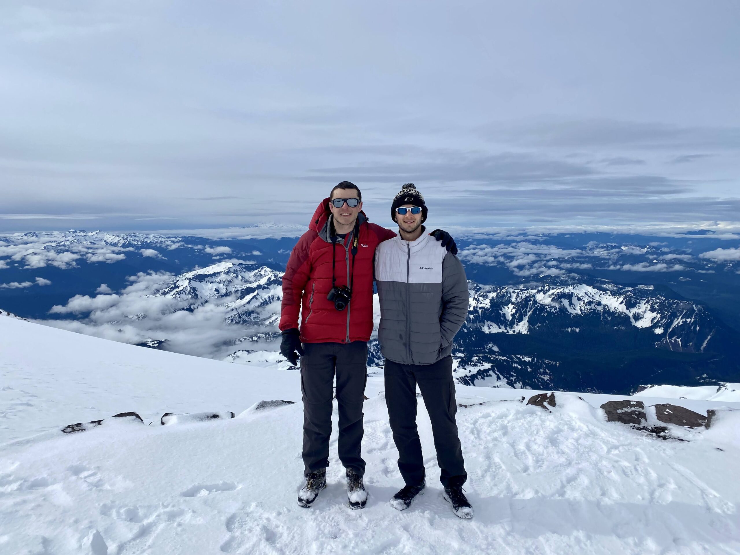
The clouds had completely cleared below 12,000 feet. While the summit up above was still covered, we could see over 50 miles to the south. Mount Adams, Mount Saint Helens, and everything in between were clearly visible. My jaw dropped. While we were at a lower elevation than we were when we summitted Mount Adams in 2021, the presence of clouds at various elevations somehow made the view more impressive. It was incredible.

I convinced Eli to join me outside, and we began snapping photos of each other with the views around us. It was a great way to start the morning.


Up above, we noticed a couple of groups descending from the Beehive, a formation on the mountain just past Camp Muir. Since the groups were descending at only 9 AM, we assumed that they had unsuccessfully attempted to summit. We later confirmed with the ranger that some guided groups and a solo group had made it up to about 12,100 feet, but then turned around when the weather quality declined. If anything, this served as affirmation of Eli’s and my decision not to summit. While I was disappointed with our inability to summit, the view ahead of us was a nice consolation prize.

Descending with a View
After sufficiently soaking in the view, Eli and I began to pack our bags. As with dinner, we skipped breakfast, opting instead to eat a few granola bars. We fastened our packs and began a quick descent down the mountain. With every step, we sunk several inches into the snow around us. However, the soft ground allowed us to bound down the slope without fear of injury. We took large and fast steps as the snow padded our landings.
Visit Paul in the Parks for more national park stories & travel tips!
Within 20 minutes, we had already descended 1,000 feet from Camp Muir. Clouds engulfed the camp one more shortly after our departure, spelling renewed trouble for anyone hoping to summit. For us, however, the weather remained clear and pleasant. The temperature gradually increased from 20 degrees Fahrenheit to 50 degrees. We maintained our view of distant mountains during our descent, a view which I frequently commented on. I donned my GoPro on the way down, having lost my chance to use it on the summit.


We maintained a steady pace down the mountain for the first 3,500 feet of the descent. We stopped a few times to chat with climbers and hikers, of which there were many more than the day before. The nice weather at lower elevations coupled with the fact that it was Saturday seemed to draw many more visitors.
Glissading
After 75 minutes, we reached Panorama Point once more. There, I talked on the phone with Maria to let her know that we were safe. 20 minutes later, Eli and I completed the most fun part of the descent: glissading. Just below Panorama Point, what was normally a steep set of switchbacks was buried in several feet of snow. Naturally, climbers had carved a glissade trail down the ~300 foot hill. Glissading – for those who don’t know – is essentially the act of using snow as a slide when it is slick enough and the terrain is steep enough. It accelerates descents from mountains and – more importantly – is tons of fun. I swapped out my trekking poles for my ice axe and followed Eli down the path. Thankfully, I captured the fun on my GoPro. Check it out.
From the bottom of the glissade trail, we completed the final 15 minutes of our descent. We passed dozens of hikers, snowshoers, skiers, and climbers before reaching Paradise. Upon returning to the car, we deposited our packs in the trunk and removed our layers. Despite the cool air, we were very hot. Almost all of my clothes were drenched in sweat or snowmelt… I couldn’t tell which.

After Eli forcefully removed a Canada Jay from his car, we stopped at the ranger station to let them know of our safe return. From there, we drove west to exit the park. I pulled over at one more stop – an overlook of the Nisqually River – before we left. I figured we may as well enjoy the scenery while in the park.


While we drove away from the park, ominous clouds and rain began to reappear. As forecasted, it looked like the mountain would get some rough weather that night. I was thankful that we descended when we did, confident that we made the right decision. Even if we had stayed another night, we would have had no better chance at summitting.
In Conclusion…
Was I disappointed that we weren’t able to summit Rainier as planned? Yes. But, was I happy with the decisions that we made? Also, yes. Ultimately, we had quite the adventure and lots of fun on Mount Rainier. We didn’t reach the top like we had wanted, but we stayed safe and returned in one piece. That should be every climber’s ultimate goal whenever they attempt to summit a mountain.
It turned out that shortening our time on Mount Rainier from 3 days to 2 days was perfect for Eli and I. It allowed us to return to Olympic National Park – this time with good weather – and see parts of the park I never had. You can read about that experience here. The decision to visit Olympic made my visit to Washington even more rewarding, further consoling me.
If only I had booked my flight a couple days later. When I left Washington on Monday, June 6th, Mount Rainier was finally seeing good weather. Camp Muir and the summit were completely free of clouds, as I saw from the plane when it took off. If I had stayed in Washington through Tuesday or Wednesday, Eli and I may have been able to pull off a successful summit. Oh well…

In the end, I learned a lot from my overnight experience with Eli on Rainier’s slopes. Since the weather in Washington can be unreliable and unpredictable, it’s smart to book a flight and permits for a full week. That way, you can plan to summit any time during that week, adapting to the weather forecast. Additionally, I learned that I need better mountaineering gear. Much of my clothing and my backpack were soaked after the trip, which would not have been a problem if I owned items built to withstand the cold and the snow. Finally, I learned that it will behoove me to climb another glaciated mountain – like Baker – before I attempt Rainier again. Better to be safe than sorry, after all.
My attempt to summit Mount Rainier with Eli will always hold a special place in my memories. I don’t know when – or if – I will be able to try again, and I don’t know what my mountaineering experience will look like in the future. Only time will tell. Stay tuned!
— Paul
Discover more about Mount Rainier National Park
Return to my National Park Guide
Return to my National Park Journal
Learn about the proper permits needed to climb Mount Rainier